Get free access to the most comprehensive World Cup coverage in The Athletic app.
Five small boats approach a cargo ship in the dead of night.
Inside the ship, among the boxes and containers, is a floodlit metal cage. On a walkway above, holding a cane and inexplicably limping, is Eric Cantona. He grabs a boxing-style dangling microphone and growls three words into it: “First goal wins.”

Thus begins one of the great football adverts: Nike’s 2002 Secret Tournament film.
If you’re reading this, there is every chance that you can conjure a few of the images that follow that opening sequence from memory. Maybe you recall Freddie Ljungberg’s rainbow kick. It could be Denilson twisting himself into another dimension or Thierry Henry using Francesco Totti’s back as a springboard.
You might remember the list of players that, over three breathless, Elvis-soundtracked minutes, turned a thousand playground daydreams into reality — or something like it.
There had been star-studded football ads before, but nothing on this scale. Secret Tournament featured 24 players. Many of them were established superstars. Some, like Ronaldinho and Javier Saviola, were still on the up. The only real outlier was Seol Ki-hyeon, not far off a complete unknown, there to represent South Korea, one of the two hosts of the 2002 World Cup. (The other host was not a problem: Nike had the stylish Japan midfielder Hidetoshi Nakata on their books.)
The story was simple: eight teams of three, a knockout tournament. This was recognisably a football set-up — Nike’s previous big football ad, 2000’s The Mission, had aped a spy thriller — but made to look edgy, frayed, clandestine. The action was technical and inventive but also anarchic, in the image of its director, former Monty Python actor Terry Gilliam, by this point a big name in Hollywood.
It was impossible to wrench your eyes away. Nearly a quarter of a century later, it still is.
With World Cup 2026 fast approaching and the latest slate of football adverts being released into the wild — including Adidas’ Timothee Chalamet-starring Backyard Legends, a spot with certain thematic echoes — The Athletic set out to get the inside track on the iconic Nike advert: the happy memories and the inspiration but also the mishaps, the internal politics, the war stories; tales of stressed creatives and moany stars; the behind-the-scenes verdict on which footballers could actually act — and which really, really couldn’t.
This is the story of Secret Tournament, told by those who made it.
Unleashing creativity
Nike had been on a run of memorable football adverts. The three that preceded Secret Tournament — Good vs Evil (1996), The Airport (1998) and The Mission — had all been produced by advertising agency Wieden + Kennedy Amsterdam, who were tasked with building on the formula ahead of World Cup 2002.
Glenn Cole, former creative director at Wieden + Kennedy Amsterdam: “Making those epics had become a tradition by then. The goal for years had been to (compete) with Adidas in the sport. When we started, we were number five or six, behind Umbro, Diadora, Lotto. The goal was to be number one by 2002 and this was the year.
“The Nike football brand was more mature, ready for prime time. They had the ‘right’ to be in the game in a more significant way. Honouring that was daunting. I remember feeling overwhelmed by the pressure of beating what we had done before.”
With the World Cup heading to East Asia, the brief was to make the accompanying advert more global than ever. Bigger, too: Nike’s roster for the promotional campaign ran to 24 players. At the same time, the brand was not an official tournament sponsor like its main rival, Adidas.
Cole: “The idea of brilliant football was our North Star. The question was how to express that on the biggest stage, knowing that we were the outsiders. ‘We’re not a formal sponsor, so how do we hijack it?’
“We were given the assets: a chrome ball, Eric Cantona, players from around the world of varying degrees of fame and skill. At the time, there was a lot of talk about the rules of the game — players getting fined, just feeling a little constricted. Our seed idea was to create a place where players could be unleashed. We thought about a set of street tournaments and started making the rules: ‘What if it was one goal wins, a high-stakes environment?’

“The idea of a tournament was embraced by Nike. It seemed like we could give a bit of structure to street football skills, which is where all the innovation is.”
The cage, the boat, the roll call
An initial idea was for the tournament to take place in a court in the backstreets of Tokyo, the players arriving on scooters. That proved unworkable. Instead, the action would take place inside a metal cage, situated in the hold of a cargo ship, all recreated in a vast warehouse sound stage in Formello, around 10km outside Rome.
Cole: “The fact it was on a barge was because we felt we needed some neutral ground. International waters seemed like a good starting point.”

Stefano Maria Ortolani, production designer: “The idea of the cage came from the agency. Once we had that, we proposed the structure with the bridge up above. It gave it two layers, two different heights.
“It was quite a big construction. We had to recreate the interior of the boat first, with all the rivets and these enormous crates, showing that we were inside the hull. It was a long process. I liked the nets made of chains; there was a very particular sound every time the ball went in. And I liked that it was all so dirty.”
As Ortolani and his team worked, the talent was being assembled. Some of the players — Ronaldo, Totti, Nakata, Luis Figo, Edgar Davids, Denilson, Lilian Thuram — had appeared in previous Nike adverts. For most, though, this was a new experience. “One ‘wow’ after another,” was how former Lazio and Spain midfielder Gaizka Mendieta described it in 2002 and that was no outlier view.

Javier Saviola, former Barcelona and Argentina striker: “It was a really nice surprise when I got the call. It was an enormous pleasure and not something I had been expecting. I felt privileged to be there with some of the best players in history. The quality was spectacular.”
Ortolani: “There were so many champions. I only realised a few years later how good some of them were. Like Ronaldinho: he was still young and wasn’t very well known at that moment.”
Cole: “The appeal was when they heard who the cast was, who the other players were. They didn’t want to not be part of what ended up looking like the top 24 players in the world. That was the draw.”
The Secret Tournament teams

Triple Espresso: Thierry Henry, Francesco Totti, Hidetoshi Nakata
The Onetouchables: Patrick Vieira, Ruud van Nistelrooy, Paul Scholes
Toros Locos: Freddie Ljungberg, Javier Saviola, Luis Enrique
Cerberus: Edgar Davids, Lilian Thuram, Sylvain Wiltord
Os Tornados: Luis Figo, Roberto Carlos, Ronaldo
Funk Seoul Brothers: Denilson, Ronaldinho, Seol Ki-hyeon
Tutto Benne: Fabio Cannavaro, Tomas Rosicky, Rio Ferdinand
Equipo del Fuego: Claudio Lopez, Gaizka Mendieta, Hernan Crespo
Top scorers: 1 — Totti, Wiltord, Mendieta, Roberto Carlos, Nakata, Figo, Henry
Chaos factor
The main shoot took about a month, just before Christmas 2001. With the European season still in full swing, the logistics of it were challenging.
Ortolani: “The players all had matches at the weekend and they only had Mondays free. We could only shoot with them then. The rest of the week was spent filming close-ups: body doubles doing tricks with the ball, just their legs visible. It usually takes around three days to do a commercial. This took weeks. It was like a movie shoot.”
Nicola Pecorini, director of photography: “It was completely nuts from a practical point of view. We had a huge crew so we could optimise the time we had with the players. On the Monday, for example, we had six or seven cameras and crews.”
On one Monday, players from Arsenal and Manchester United shared a flight to Rome the day after a Premier League game between the two sides. Arsenal had won; Ruud van Nistelrooy and Paul Scholes especially weren’t best pleased at having to see their rivals again. “I f**king hated it,” Scholes said on The Overlap last year. Tim Wolfe, the copywriter on the ad, told The Times in 2022 that Scholes was “in a really bad mood, really hard to direct”. There were other issues, too.

Ortolani: “At one stage, Figo had an injury, something with his leg. Imagine! Everybody was very, very worried about it. It wasn’t anything serious but still… you know, he was playing for Real Madrid.”
Pecorini: “For whatever reason, the various Nike departments decided to combine the players in the worst possible way, practically speaking. We never had the winning team – Henry, Totti, Nakata – on set together. Never. They were never in the cage at the same time. It was crazy.”
Hidetoshi Nakata, former Parma and Japan midfielder: “We shot individually. I never saw the other players.”
Pecorini: “The players we had most were the ones based in Italy. It was easier for them to get there. But they went in and out with private jets and all that stuff. Nike were paying. I have no idea how much it cost them.”
Ortolani: “It would be impossible to make today. Players play every day of the week and you could never schedule them like we did.”
Let the ball decide
Inside the cage, there was no fixed plan. In the first instance, it was up to the players themselves to come up with the flicks and trick shots that would eventually make the final clip.
Pecorini: “The action wasn’t scripted. There was a lot of improvisation. The first-goal-wins rule was about it. A lot of the suggestions about what they could do came from the players themselves. They had ideas… how to use the bounce, use the corners, things like that.”
Cole: “We started with the most creative players, the ones who naturally just show up and have a sense of play. The Brazilians set the tone. Once you get young, elite footballers watching others do something spectacular, their inner competitor comes out. You can’t really stop them at that point.
“The only scripted thing was the ending, with Henry doing the header and Roberto Carlos trying the scorpion kick to stop it. The rest was improvised. You pick the best of it; there were plenty of failed attempts.”


There were a couple of tricky dynamics to manage. Clips like this are mostly about flair and technical skill; defenders are sometimes condemned to less glamorous roles. Then there is the need for the narrative to trump individual egos: Van Nistelrooy, in the form of his life for Manchester United at the time, did not enjoy being told to miss on purpose for one shot.
Cole: “You set up these one-on-ones with these guys who play against each other in big Champions League matches. Somebody has to win and somebody has to lose. So of course there is a bit of, ‘Er, no, we’ll see about that. Let’s see what happens’.
“All the guys were pretty professional. It’s not like they’re construction workers, but they show up ready to clock on. They really care about their craft, want to get each move right. You or I may see something and think it was incredible, but they’re like, ‘No, when I chested it, it came a bit too far from my body. It didn’t look perfect. Let’s do it again’.
“They were perfectionists.”
Playing for laughs
While the players’ technical skill shone through, not everyone was so convinced about the quality of some of the acting on display. Some of the stars, meanwhile, were more excited to be on set than others.
Pecorini: “The majority of the crew were Roma fans. That was the peak of Francesco Totti’s career. He was god to anyone who cared about Roma. Whenever he came on the set, the crew were all in awe. Maybe now he’s better, but back then he was very shy and clumsy. You’d ask him to look surprised, and he’d give a look of terror. So after the third or fourth take, my key grip, who is a lifelong Roma fan, went over, patted him on the back and said, ‘Capitano, stick to football, OK? You’re not cut out for acting’.”
Saviola: “I was there with Ronaldinho, Figo, Claudio Lopez. Cantona was there. Edgar Davids and Hernan Crespo too. I didn’t feel any pressure to perform. I still have a signed photo of the cast in my personal museum. They’re incredible memories.”
Pecorini: “Ronaldo wasn’t happy to be there. At that time, most of his time must have been taken up by promotional shit. I think he’d had enough. Ronaldinho was completely crazy. He was like a kid in the Charlie and the Chocolate Factory. High energy, being foolish with the other guys. ”
Cole: “Ronaldinho was a natural. Denilson was a natural. Those guys are just entertainers, funny from the minute you meet them. They’re just big kids. Roberto Carlos also. Thierry Henry had great presence. He was a good performer — funny, smart.”

Pecorini: “Figo was good fun and he could act. He was good at understanding where the camera was. He was also probably the only one there with whom you could talk about something other than football, too.”
A lot of the energy on set was provided by doubles — jobbing actors who resembled the players enough to pass as them in quick cut-aways shots — and by a prankster on the crew.
Pecorini: “Some of the doubles were jugglers and freestylers. Others were more lookalikes. I can spot a few things in the editing.”
Cole: “The guy we always had the best double for was Roberto Carlos. Spitting image, Brazilian, great footballer, had the same nose, the giant thighs. Everything was identical. I think he played football in division two or three somewhere.
“The doubles stayed with us for the whole shoot, so this guy was in Rome with us for weeks. We used to go out with him and constantly get free dinners. If we couldn’t get a table, I’d just kind of gesture at him, not even say anything, and they’d be like, ‘Oh my God, it’s Roberto Carlos!’ They would clear a space and get a table for us. There would be kids coming up and asking for autographs. It got weird. I didn’t tell him to sign autographs!”
Pecorini: “There was a very funny guy called Marinese. He was this big, prehistoric grip. Whenever a new player came in, he immediately went over and asked for a photo. He had a Polaroid camera. The footballer would agree, they’d take the picture, the Polaroid would come out, and Marinese would give the picture to the player. He would say, ‘Good, now you have a picture with the famous Marinese, you can keep it’. They were all so confused by it. It was fantastic to see their faces. He flipped the whole thing. Maybe one of the players still has the photo and is still wondering who this guy Marinese is.”
Problem solving
With so many moving pieces, it was inevitable that the shoot would throw a few curveballs to the producers.
Ortolani: “We had a few technical problems. Roberto Carlos kicked the ball so hard at one point that he broke the side of the set.”
Pecorini: “Terry (Gilliam) wanted this big contrast, so I used these very strong lights. You would normally use them from 100ft away, but I put them 12ft above the players’ heads. We had issues because they were so strong. Although we would dim them down when we weren’t shooting, the beam would cook the turf.”
Ortolani: “We had to change the grass three times because it went yellow. We tried painting it but the players got all dirty when they fell down.”
Pecorini: “Terry came to the dolly grip, who had this long track along the side of the cage, and said, ‘OK, we’re filming Thierry Henry. Stick with him’. And this guy had the dolly, which is like a 300kg thing on wheels. If there is one famous thing about Henry, it’s how fast the motherf***er was! ‘Stick with him!’ The guy was like, ‘Err… yeah, sure!’

“On the Wednesdays, when the players weren’t there, we would shoot little details: the ball going in in a certain way, rattling the chains, the double bounces. It sounds silly but those things take so much time. There weren’t many visual effects back then, so you couldn’t rely on that. Now, they’d say, ‘Don’t worry, just shoot the corner, we’ll add the ball in later’. Back then, you shot the corner and then the ball doing what you wanted it to do.
“There is only one visual effect. Because the three players on the winning team were never actually together, they stuck Nakata’s head on a double’s body. But just for a moment: there’s one shot with the three of them. Nakata’s face there was spliced on later.”
Former Borussia Dortmund playmaker Tomas Rosicky only appears for a brief second, shot from behind. Two players — Seol and Fabio Cannavaro — are not discernible in the final edit at all.
Pecorini: “There were so many of them.”
Cole: “They’re somewhere, aren’t they? Are their faces there? S***! I have to watch it again. I distinctly remember asking them to cover everybody. They were there, on set. Whether they were spectacular enough for the three-minute edit, I don’t know…”
Wolfe, the copywriter, has spoken about a moment that highlighted some of the risks involved in the shoot: Claudio Lopez, then of Lazio, slamming into a panel and falling out of the cage. Luckily, he was unharmed.
Pecorini: “There was more than one incident. It looked really good, but it wasn’t designed with safety in mind, put it that way. I’m amazed that more players didn’t get scratched. The steps to go in and out of the cage were steep and short. With football boots on, it wasn’t the best. We were pretty lucky.”
Saviola: “I don’t remember the thing with Claudio but we were moving around the cage a lot and it was… I wouldn’t call it dangerous, but we weren’t used to playing with camera equipment all around. The possibility was there.”
Cole: “I’m not sure how we’d do this spot today. I don’t think you could, or at least not the way we did it. Terry respected the players’ safety but I was really pushing them to play. The ball wasn’t getting kicked hard enough off the fence for fear of it hitting someone in the face. If it’s not intense, it looks fake, (so) I was being whiny about that.
“Next thing you know, they’re shoving each other into the cage, fingers are getting caught. I don’t know if you could shoot that with today’s safety standards. It was one of the last edgy ones.”
Eric and Terry
If there is a main character in the advert, it is Cantona, cast as a roving master of ceremonies on a gantry above the pitch. It might all have been different, however: the man initially scouted for that role was Italian referee Pierluigi Collina.
Cole: “We were thinking that he would be the guy. But then we were like, ‘Well, the point of this is supposed to be anti-rules, play how you want, football at its most pure’. We decided we should probably have no ref, but instead some kind of host, more a voice of the game. Eric was the natural choice.”
Pecorini: “He was probably the one who had the most fun. I had worked with him before, on the Airport advert, so it was like seeing an old friend. He is a very funny guy. And, I think, having seen what he did after, a decent actor. Much better than Totti. If I had to choose people to go to dinner with, out of all those guys, I’d pick Figo and Cantona.”
Cole: “Eric was always a very eccentric personality in and outside football, but he was easy and fun. He did a good job of keeping the players in a light mood.”

It is safe to assume that Cantona, a cinephile, was more excited than most of the players to be working with Gilliam. The director was a left-field choice to direct the advert, but threw himself into the project.
Cole: “He really embraced it. What he’s really brilliant at is creating a world that has some quirks, that feels real enough. So when it came to environment and atmosphere — the look and feel of the thing — he was just a home run. And although he’s not naturally a football fan, he treated the players like actors delivering performances, and invited them to be themselves. He nailed it.
“Keeping the atmosphere cool and weird was where his genius showed up. Early on, we were on this gloomy stage, in this rusted metal cage, and we’re asking players to be brilliant at 10am. It just didn’t feel loose enough. I spoke to Terry and he said he would try something. He went to the back part of the set and started banging this giant metal prop chain on some barrels and shouting rhythmically. He was trying to make music with it. I remember looking at him and thinking, ‘If this was a Monty Python sketch about this commercial, I would totally believe it’.”
It was not all plain sailing. Ad shoots tend to involve entire armies of stakeholders. Gilliam sometimes bridled at the number of voices in the room.
Pecorini: “He doesn’t like making commercials because he doesn’t like having to deal with agencies. And this one was like agency squared, because there were lots of people involved. He’s always very confrontational — sometimes too much. Very often he’s right, but sometimes you think, ‘Just drop it’, you know?”
Ortolani: “Yes, he was annoyed. It was Nike people, the players’ agents and entourages. It was a nightmare. People were asking him questions constantly. He was a bit upset by it all. He wants to work, not just talk.”
Pecorini: “If you are within the Nike ranks and you have the opportunity to come to Rome for three weeks, expenses paid… even if you don’t have anything to do, you find a way to be necessary. They had to justify the fact they were there by coming up with completely pointless things. It’s like, ‘You’re in Rome, go have an ice cream and come back later’. But no.
“One night, we had to shoot the exterior of the ship, in the harbour. There was a big thing with the permits and customs. Two hours before call time, Terry told me he wasn’t coming. ‘If I come, I’m going to get in a fight with those assholes. You do it’. I said, ‘Yeah, can I have your salary for the night as well then?’ If you have any idea of what a director’s fee is, you’ll know why I wanted that.”
Cole: “Feature directors are not used to having another person in their ear. But in advertising you’re generally right there, making decisions together on every shot. I do think that drove Terry a little nuts.
“In the first week, he told me to go and sit in a corner. He yelled at me. Frank Hahn, the art director, printed shirts for the whole crew the next day. They read, ‘Terry Gilliam told Glenn to go sit in the corner’. And I had one that said, ‘Terry Gilliam told me to sit in the corner’. That really broke the ice with Terry, actually. Things went really well after that.”
Pecorini: “There were also some stupid things. Seol, the South Korean player, refused to be on the same team as Ronaldinho, if I remember right. But it wasn’t him; it was Nike South Korea who didn’t want it. Because Ronaldinho was nobody at that stage, globally. They wanted a bigger name. We lost so much time sorting that out.”
Cole: “Terry is more used to acting and comedy than football players — and being threatened by agents and managers.”
Remixing Elvis
One of the most memorable things about the advert is its soundtrack: a remix of the Elvis Presley song A Little Less Conversation by Dutch musician Junkie XL. After the advert’s release, the track went to number one in the UK, Australia, Canada and beyond.
Cole: “The music was a real monkey wrench. We just could not land the right track to pull it together. If you turn the audio off and try to follow this thing, it’s pretty hectic beyond the colours of the jerseys. There was just no obvious tone or tenor. We tried rock, metal — dark, intense stuff — but it didn’t really underscore what we were seeing.
“We talked to all sorts of music producers, contracted a band, some hot producers. They brought in stuff to play, and we were very polite, but I remember thinking, ‘Oh my God, this is a disaster’.
“A couple of the guys went to watch Ocean’s Eleven, which had just come out. There’s the shortest clip in that movie when you hear the loop from A Little Less Conversation, the original. We put it on the next day and I thought it had a fun, free-wheeling, gambler’s sort of vibe. And the theme was cool. A Little Less Conversation — just shut up and play.
“It felt dated, so we wanted to modernise it. I called a friend in Amsterdam, Tom Holkenborg. Junkie XL was his stage name. I asked him if there was anything he could do by the next morning. The following day he played it to me over the phone. It sounded amazing, 80 per cent there. We presented a final version to Nike; it was a split room at first but people started to fall in love with it.
“It’s very hard to clear music tracks. Elvis had never licensed anything to be used for commercial purposes. His estate was famously against it, but our contact at the label flew to Graceland, spoke to them about the power of global football. He also said it had the potential to break a long-standing tie between Elvis and The Beatles for number-one hits globally. That might have sparked their competitive interest. They agreed to let us use it. I couldn’t believe it.”
Legacy
Secret Tournament was a smash hit. Football fans around the world adored it; kids tried to replicate the moves in playgrounds on every continent. Wieden + Kennedy won two prestigious Golden Pencil awards for the campaign. Even today, it holds a special place in many people’s hearts — not least the people behind it.
Ortolani: “It is the most popular commercial I’ve done. Absolutely. People all over the world saw it.”
Saviola: “I was really happy when it came out. My family and friends all sent messages. They were all surprised — firstly with how good the final product was but also the impact it had. It was seen all around the globe. And everyone remembers it, even today.”
Cole: “Nike loved it, from what I understand. I think it was good for their culture and good for business. It’s up there with my personal favourites. It’s the one that people bring up the most. The fact people are still talking about it is awesome.”


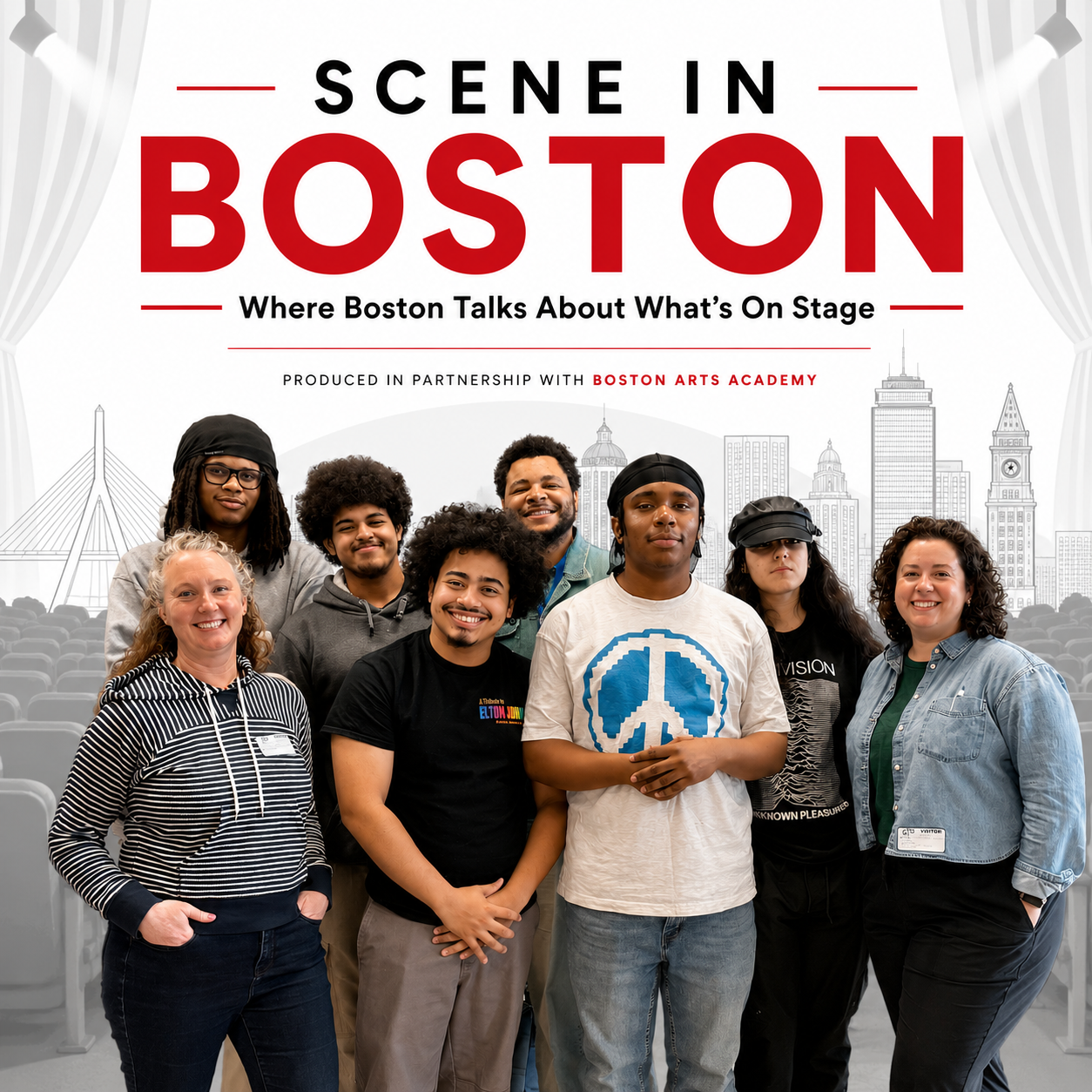 Laura Amico (front row, left), a 2013 Nieman Fellow, and Lisa Thalhamer (front row, right),are co-hosts and co-creators of "Scene in Boston," a new podcast exploring Boston's theater community. Produced in partnership with the Boston Arts Academy, the city's only public arts high school, the podcast includes students on its production team. Students pictured (back row, from left): Michael Finley, Alex Storm, teacher Joshua Jackson, and Charlotte GS; and (front row, second from left): Avant Moro Flack and Sebastien Antunez. Samiyah Cox